| Garmin Fish Finder & GPS
Garmin Echomap UHD2
They say locals know best. But anyone who says that hasn’t fished
with the ECHOMAP UHD2 5” and 7” chartplotters with clear, crisp sonar and
mapping.
Garmin Echomap Ultra
With big, crisp, sunlight-readable
touchscreen displays, these versatile chartplotters put a world of fishfinding
capability at your fingertips. They’re available with built-in Garmin Navionics+™
mapping, and the transducer bundle adds Ultra High-Definition scanning sonars as
well as CHIRP traditional sonar.
Garmin Striker Vivid Fishfinder
See fish and structure in colorful
detail with the STRIKER™ Vivid fishfinder. This easy-to-use 7” device now
features high-contrast color palettes to make it easier to see what’s beneath
the surface.
Garmin 700 - 8000 series GPS Fishfinders
The easy-to-use, easy-to-install chartplotter/sonar combo
delivers MFD performance in a combo-size package.
Call Tech Support at (800) 800-1020
|
GPSMAP® 8400/8600 Series
Now includes 10”, 12” and 16" chartplotter/sonar combo models with full in-plane
switching (IPS) touchscreen displays, support for traditional, scanning and
Panoptix™ sonar, preloaded coastal charts and inland maps featuring Navionics®
data and Auto Guidance technology
GPSMAP® 74xx/7600 Series
Choose from 7”, 8”, 10” 12” or 16” chartplotter/sonar combo models with
touchscreen controls, support for traditional and scanning sonar, built in
coastal charts and inland maps, networking capabilities and WiFi connectivity
GPSMAP® 7x2/9x2 & 12x2 Touch Series
Choose from 7”, 9” or 12" chartplotter/sonar combos with touchscreen controls,
traditional and scanning sonar capabilities, coastal charts and inland maps,
networking capabilities and WiFi connectivity
GPSMAP® 10x2/12x2 Series
Choose from 10” or 12” chartplotter/sonar combos with traditional and scanning
sonars, preloaded coastal charts and inland maps featuring integrated Garmin and
Navionics® content, networking capabilities and Wi-Fi® connectivity
ECHOMAP Ultra Series
Choose from 10” and 12” models with keyed-assist touchscreen displays, built-in
support for our premium sonars and preloaded LakeVü g3 and BlueChart® g3
cartography
ECHOMAP Ultra Series
Choose from 10” and 12” models with keyed-assist touchscreen displays, built-in
support for our premium sonars and preloaded LakeVü g3 and BlueChart® g3
cartography
echoMAP™ CHIRP Series
Choose from 4”, 5”, 7” or 9” models featuring industry leading traditional and
scanning sonar, coastal charts and inland maps
What is CHIRP?
CHIRP is the most sophisticated sonar technology
available for use by the fishing and boating public. The word itself is an
acronym for Compressed
High-Intensity Radiated Pulse.
Standard Sonar
Standard sonar sends 1 single frequency at a time.
Since the only feedback is from this 1 single frequency, there is little
information to work with, limiting the clarity and resolution available with
standard sonar.
CHIRP Sonar
Instead of sending just 1 single frequency, CHIRP
sends a continuous sweep of frequencies ranging from low to high. CHIRP
sonar technology then interprets frequencies individually upon their return.
Since this continuous sweep of frequencies provides CHIRP with a much wider
range of information, CHIRP sonar is able to create a much clearer, higher
resolution image.
CHIRP Scanning Sonar
CHIRP technology also enhances the performance and clarity of Garmin DownVü and
SideVü scanning sonar to provide the clearest sonar images on the water.Types of Sonar
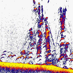
Traditional HD-ID™ Sonar
Traditional sonar that is available on Garmin fishfinders. HD-ID sonar
transmits two frequencies, generally either 77/200 kHz or 50/200 kHz. Our
echoMAP and GPSMAP chartplotter/sonar combos have Traditional HD-ID sonar
built in.
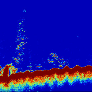
CHIRP Sonar
CHIRP sonar transmits a sweep of many frequencies within a long duration
pulse. The equivalent sound energy is hundreds of times greater, resulting
in more energy on target. This provides huge advantages in detail,
resolution and accuracy at much greater depths. CHIRP is built into our
GPSMAP chartplotter/sonar combos
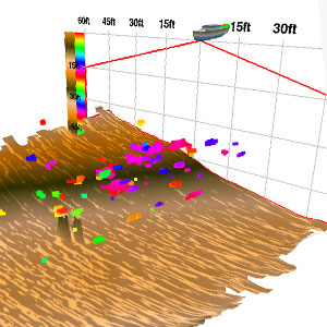
Panoptix™
Panoptix™ all-seeing
sonar is unlike anything you’ve ever seen on the water. Use the Panoptix
Forward or Down transducer with a compatible Garmin GPSMAP unit to see all
around your boat in real-time. You can see fish in the water column in
3-D. You can also see your bait cast into the water and watch it as you
reel it in. You can see fish swimming in front of or below your boat. You
can even see them chase your lure. But
to truly appreciate Panoptix, you have to see it.
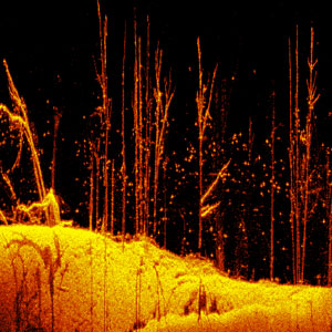
DownVü Scanning Sonar
This high-frequency sonar gives you a clearer picture of what's below your
boat, by producing a more detailed representation of objects, structure
and fish. DownVü with CHIRP technology takes it one step further,
producing an ultra-clear page with even more detail. DownVü scanning sonar
is built into our echoMAP combos, and DownVü scanning sonar with CHIRP
technology is built into our GPSMAP combos.
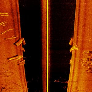
SideVü Scanning Sonar
SideVü shows you what is happening to the sides of your boat. An excellent
way of finding structures and fish. SideVü with CHIRP technology provides
an even more detailed and higher resolution image of what is beneath the
surface. SideVü scanning sonar is built into our echoMAP sv combos, and
SideVü scanning sonar with CHIRP technology is built into our GPSMAP
combos.
Mounting Styles
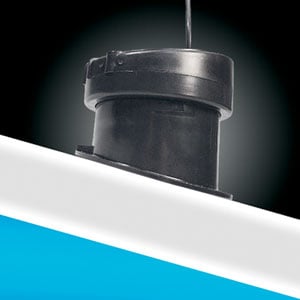
In-Hull
is installed inside a boat hull against the bottom and sends its
signal through the hull.
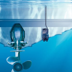
Transom
is attached to the back (transom) of a boat hull.
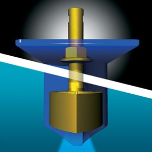
Thru-Hull
is installed in a hole drilled thru the hull.
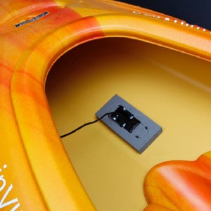
Kayak In-Hull
attaches to the inside of a kayak, against the bottom and sends its
signal though the hull.
Additional Information
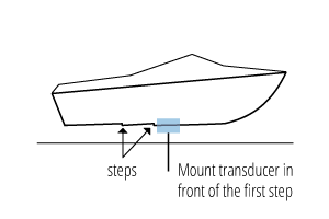
Stepped Hull
A stepped hull contains a notch (or step) that runs crosswise across the
boat hull and helps the boat generate more lift at higher speeds. If
transducer is mounted after the notch, the notch creates cavitation and
will interfere with sonar returns. For this reason, the transducer should
be mounted in front of the notch, closer to the front of the boat.
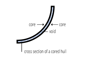
Cored Hull
A cored hull refers to a hull with a void between the 2 layers of hull
material. Sonar cannot transmit through that void.
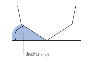
Deadrise Angle
The deadrise angle is the angle between the horizontal line of the water
and your boat's hull
|
|
|
|


